
Yesterday’s Weather
The visible satellite shows the thunderstorm locations for yesterday afternoon. The strong winds aloft blew the anvils to the northeast, with precipitation along the western edge of the anvil. Most of the storms remained in the mountains, although an outflow boundary did kick up a few short-lived storms in the Phoenix area.
The HRRR-UAWRF 12Z forecast (below left) was very similar to the actual storm locations (below right).
Analysis
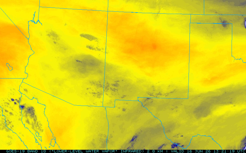
The water vapor satellite imagery below shows two upper-level lows. The first one is near Brownsville and may form into a tropical storm as it moves along the Texas coast. The second one is in the tropical Pacific and is moving northeast. This low-pressure system has been providing mid-level moisture over Arizona, which supported yesterday’s storms. The axis of moisture flow has shifted farther east into New Mexico.

The low-level water vapor satellite imagery shows moisture from Kingman southeast to the Mogollon Rim, then to southern New Mexico. Graham and Cochise counties have seen increased moisture, and these areas should be the focus of thunderstorm activity today.
The Phoenix sounding shows a little low-level moisture and cooling below 850mb. The moisture is due to the outflow from yesterday’s storms. Around 500 mb, there is an inversion indicating the height at which the base of any storms forming this afternoon would be. Precipitable water is only 1.22 inches (31 mm), and rain falling through the atmosphere will probably evaporate before reaching the ground; this sounding is typical of dry thunderstorms. Except for a layer around 550mb, all the winds are from the west, confirming we’re still technically not in a monsoon flow pattern. The HRRR-UAWRF 12Z initialization (below left) matches the observations well, with only fractionally less moisture (PW 30mm) and warmer surface temperatures (89°F vs 84°F observed).

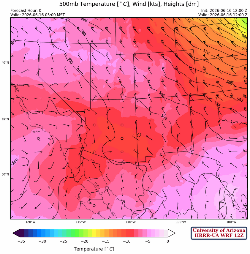
At 250mb, the trough has dropped south into northern Arizona/New Mexico, and a second trough is over the Baja moving eastward. The monsoon ridge has been displaced farther south into central Mexico. The location of the subtropical jet is given in red and the polar jet in blue. Once the monsoon ridge moves back to the Four Corners, the subtropical jet will be gone for the summer.

At 500mb, no real sign of the monsoon ridge at this level, with winds aloft light and northerly in Arizona and from the northwest at 10 to 15 mph in New Mexico.
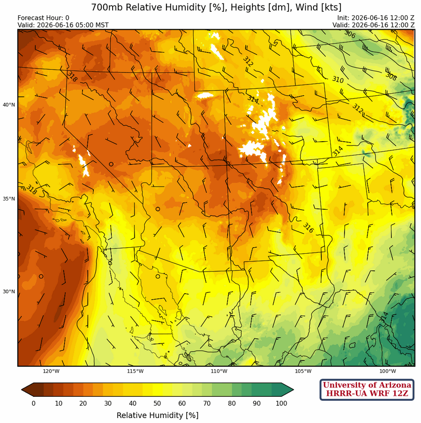
At 700mb, the northerly winds around a high across the northern Gulf of California is bringing dry air into the region from the Great Basin. The developing tropical system near the Texas coast has cut off moisture flow into Mexico and it will take a few days for the flow to return.
Today
The dry air filtering into the region from the north will suppress storms today for most of Arizona, with the main focus of activity in Santa Cruz County. With reduced moisture today, the main threat is outflow gusts.
Tomorrow
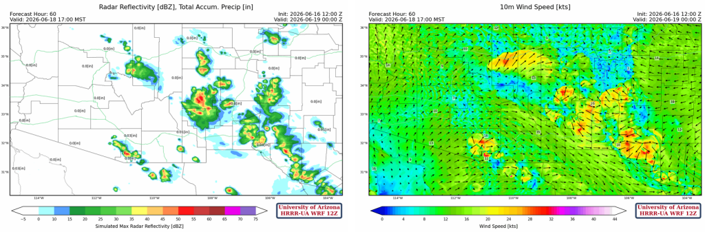
The HRRR-UA WRF 12Z radar reflectivity forecast (below left) and GFS-UA WRF 06Z forecast (below right) show more widespread storms again tomorrow, with activity in the White Mountains, Yavapai, Pinal, Pima, Santa Cruz, and Cochise counties. The question is, where is the moisture coming from?
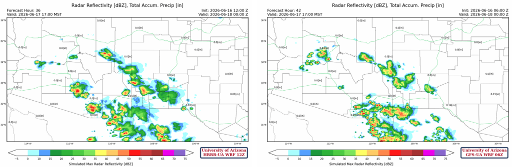
Possibly from the Gulf of California in the low levels, given the 10-meter wind speed forecast tomorrow (below). But this seems iffy at best, and the more likely scenario is some storms with less areal coverage, with storms remaining in the mountains. If you remember, there was one ensemble member from yesterday that was like this forecast. The good news is that we have several more model runs today to see how this is resolved. Note that if this forecast is correct, there are a lot of strong winds across the southern portion of the region.

Outlook
Most storms have shifted eastward into New Mexico with only a few mountain storms in Arizona. Microbursts in Arizona may be a little overdone; we’ll know more tomorrow.
The thunderstorms for tomorrow evening will drop less than a tenth of an inch of rain, then the moisture is gone.
Long-range models keep us dry for the weekend and into next week, but more moisture is predicted to return around June 28 and beyond; though there’s significant uncertainty that far out.
Discussion written by Pat Holbrook and Patrick Bunn